Geocoding is the process of converting a location description, such as a physical address, into precise latitude and longitude coordinates. This powerful feature, combined with census data from the United States Census Bureau, provides valuable information to better understand the communities your program serves.
Proceed as follows to effectively leverage these location-based data points within Insights to enhance your reporting and decision-making.
Step 1: Understand Geocoding and Census Terminology
- Geocoding - The process of converting a location description into latitude and longitude coordinates.
- Census - The United States Census Bureau, the federal government's largest statistical agency, provides current facts and figures about America's people, places, and economy. (Source: census.gov)
- CRA - The Community Reinvestment Act enacted by Congress in 1977 is a federal law that encourages financial institutions to help meet the credit needs of the communities in which they operate, including low-to-moderate income (LMI) neighborhoods. (Source: occ.treas.gov).
- FFIEC - The Federal Financial Institutions Examination Council, an interagency that sets regulatory standards and principles for financial institutions. (Source: ffiec.gov)
Step 2: Assess which Values are Assigned Using Geocoding and Census Data
If a complete address has been captured within the standard Organization, Volunteer Event, or Donor location fields, that address is then automatically assigned geocoded values (e.g., Latitude/Longitude, Census Tract, MSA, CSA, etc.). Additionally, the populated geocoded values, combined with the Census Year, will then determine the accurate census data that will be populated.
Important Notes:
- Only standard Organization, Volunteer Event, or Donor location fields will be automatically geocoded. We do not support automatic geocoding for custom location fields.
- Only US addresses will be geocoded, with the exception of P.O. Box addresses.
- We currently only support census-based fields for organizations or volunteer events and do not support this level of location detail for donors.
- We automatically look for and geocode new or updated addresses once daily.
Step 3: View Geocode & Census fields in an Explore
Analysts can navigate to Insights and choose an Explore that uses geocoding to apply fields or filters to their data table.
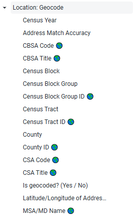
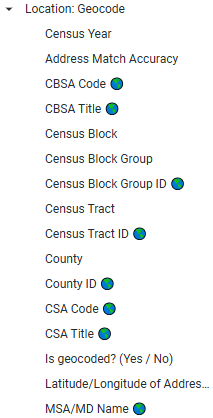
- Geocoding fields can be found within the "Location: Geocode" folder of the field picker in any Insights Explore containing Organization, Volunteer Event, or Donor data.
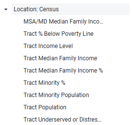
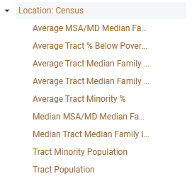
- Census fields can be found within the "Location: Census" folder of the field picker in any Explore containing Organization or Volunteer Event data.
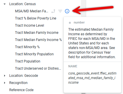
Review the available fields and their descriptions by clicking the information icon next to each field within the field picker or refer to the Insights CRA Reporting Data Dictionary.
Step 4: Understand the Source and Availability of the Data
Geocoding values are sourced from Geocodio (Geocod.io). Census values are sourced from the FFIEC (FFIEC.gov), prioritizing the most common fields used within the FFIEC geocoder tool.
- The census data available in Insights covers the years 2019-2023, with the most recent year's data being used if a future year is selected.
- The year of census data is dynamically dependent on the year that has been selected within any date filter and can be confirmed by the year populated within the Census Year field. However, we will only return census data for the years 2019 to the current year. If the following year is included in the date filter, then the most recent census data will be returned. Once the new year's data has been made available by FFIEC, it will then be loaded into Insights. Any years outside of this will return a null census value.
View the Insights CRA Reporting Data Dictionary for a more detailed description of the Census Year field value.
Step 5: Visualize Geocoding and Census Data on a Map
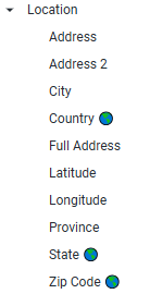
In addition to our standard location fields that can be represented on a map (Country, State, County ID, and Zip Code), we support mapping for the following geocoding fields: CSA, MSA, CBSA, Census Tract ID, and Census Block Group ID.
- Geocoding fields that can be visualized on a map are indicated by a globe icon next to the field name.
Step 6: Identify Geocoding Success and Analyze Census Data
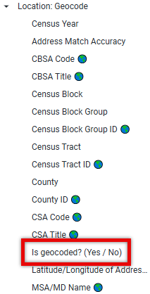
- Analysts can use the "Is geocoded? Yes/No" field located within the Location: Geocode Dimension (black fields) applied as a filter or within your data table to identify addresses that were not successfully geocoded.
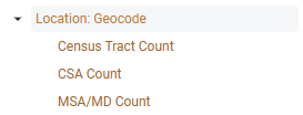
- Analysts can leverage the Location: Geocode Measures (orange fields) to calculate counts of CSAs or MSAs that were impacted by your programs.
- Analysts can utilize the Location: Census Measures (orange fields) to analyze average census values across multiple events or organizations. We recommend utilizing the Census Measures from the field picker, instead of the Dimension (black fields), as the measure will provide an aggregation across multiple records.
What else do you need help with?
Not what you're looking for? Navigate to Understanding CRA Reporting within Insights